Whether you're new to AI-powered streamflow forecasting or looking for a deeper understanding of core concepts, this guide is for you. We've curated the most important terms to help you navigate the intersection of artificial intelligence (AI) and hydrological forecasting — with special attention to how these concepts apply in HydroForecast.
Core artificial intelligence & machine learning concepts
These foundational terms explain how models learn from data and what's happening under the hood of HydroForecast models.
Artificial Intelligence (AI)
Artificial intelligence is the broad field of computer science focused on creating systems that can perform tasks typically requiring human intelligence like pattern recognition, decision-making, and prediction. In streamflow forecasting, AI often takes the form of machine learning models that learn complex hydrological relationships from historical data, rather than relying solely on hand-coded physics equations tailored to a single basin.
Machine Learning (ML)
Machine learning is a subset of AI where algorithms learn patterns from data without being explicitly programmed for every scenario. In HydroForecast, we use a theory-guided machine learning approach — specifically, a type of neural network called a Long Short-Term Memory (LSTM) network. This allows the model to learn from data across many locations. By spotting patterns in large datasets, like how streamflow responds to rainfall or snowmelt, ML helps the model adapt to new conditions and make predictions in new places.
Why it matters: It's what enables HydroForecast to be both flexible and scalable, making accurate predictions even in basins with limited historical data.
Deep learning
Deep learning is a subset of ML that uses multi-layered neural networks to learn richer, more complex relationships in data. It's the same technology behind image recognition and voice assistants, and LSTM models fall into this category. In HydroForecast, deep learning helps capture the subtleties of hydrology, like how snowmelt timing interacts with soil saturation in a particular region, that traditional models might miss.
Transfer learning
Transfer learning allows a model to build on what it has already learned. Instead of training from scratch for each new basin, we start with a base model trained on many basins and then fine-tune it for the new location.
Why it matters: Transfer learning is especially valuable in data-scarce areas where historical observations are limited. It gives the model a head start and cuts down on training time.
Base model
The base model is the core version of HydroForecast before it's tailored to a specific basin. It's trained on data from many regions and learns general hydrologic behavior. From there, we fine-tune it using local data so it can account for basin-specific characteristics for individual customers. The base model can also be run without any further tuning at any gauged or ungauged location.
Training and tuning
Just like people, models need training. Training means feeding the model historical data (which we also call the training data) so it can learn how rivers in a region typically behave. For streamflow forecasting, training data typically includes years of past observations: precipitation, temperature, snowpack, soil moisture, and measured streamflow. The model learns by finding patterns in this data — essentially figuring out what conditions lead to high or low flows. The quality and quantity of training data directly impacts forecast accuracy.
Tuning is the process of adjusting the model to improve accuracy, often by zeroing in on local data. The better a model is trained and tuned, the better it can generalize from the past to predict the future.
Data and inputs
Accurate streamflow forecasts depend on quality inputs — from on-the-ground observations to the latest weather data.
Gauge
A gauge is a stream‑flow monitoring station that provides measured data of streamflow rate or level. An "ungauged basin" lacks that direct measurement. In HydroForecast, ungauged basins are important because we often use transfer learning or other methods to fill in gaps when measurements are sparse.
Read about forecasting in ungauged basins.
Weather inputs
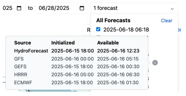
HydroForecast ingests data from multiple global weather models — including ECMWF, GFS, GEFS, and HRRR — prioritizing the most current data available. Rather than relying on a single source, combining models creates a more robust and resilient forecast: if one model underperforms in a given region or condition, others compensate. Weather forecasts are updated frequently, so HydroForecast checks for new inputs every two hours to ensure streamflow predictions reflect the latest atmospheric conditions.
Learn more about how frequently updated weather data drives forecast accuracy.
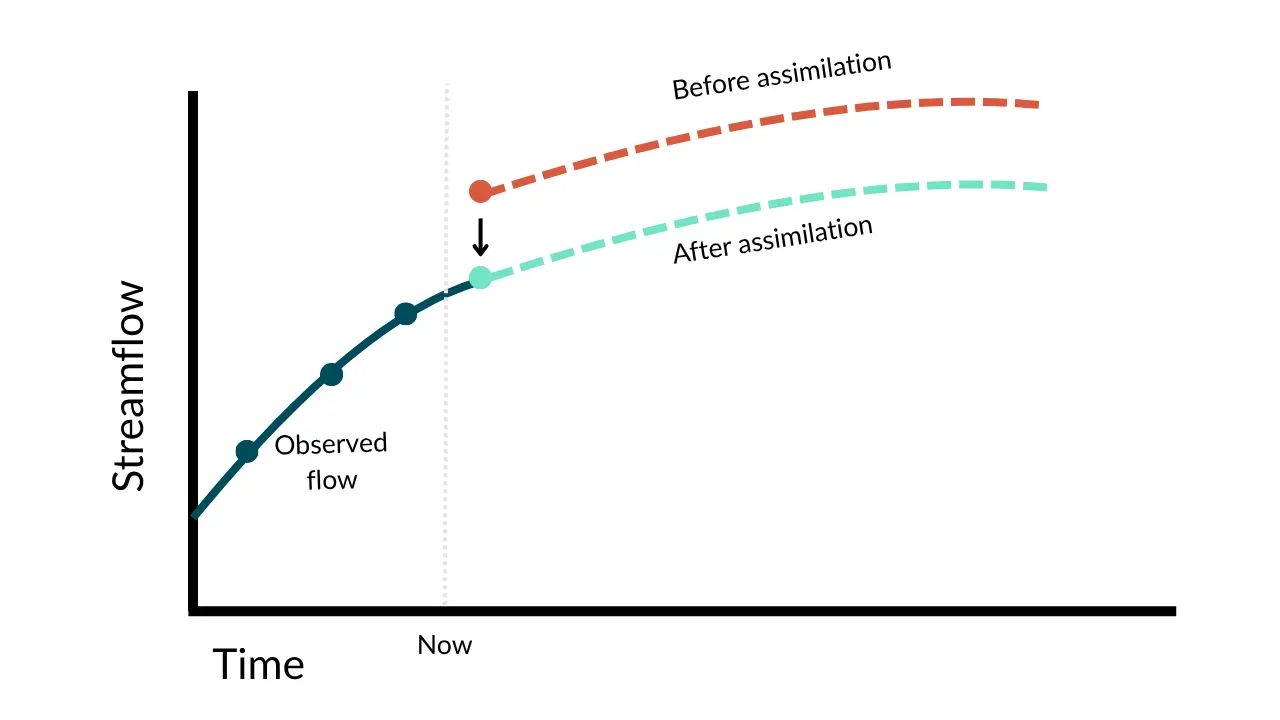
Data assimilation
Where gauge data is available, HydroForecast pulls in the most recent streamflow observations and nudges the forecast to align with current reality, staying up-to-date with the latest ground conditions. Think of it like a GPS recalculating your route when you miss a turn.
Why it matters: Assimilation ensures forecasts reflect actual conditions, improving accuracy especially in the first few days of the forecast horizon.
Read more about assimilation and why it matters.
Forecasts, predictions, and model outputs
These terms help you understand types of forecasts and interpret HydroForecast predictions.
Probabilistic forecasts
Instead of giving a single answer or outcome (aka a deterministic forecast), probabilistic forecasts show a range of possible outcomes. In the HydroForecast dashboard, the 50% and 90% confidence intervals are displayed along with the mean forecast. That means you can see not just what's likely to happen, but also what's possible.
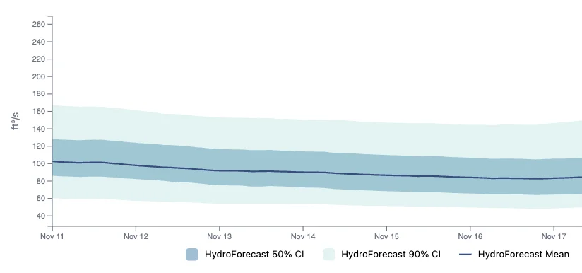
Why it matters: It's a way to plan for uncertainty. If the 90% interval is wide, you know to prepare for high uncertainty; if it's narrow, you can be more confident in your operational planning.
Read more about visualizing uncertainty with confidence intervals.
Forecast horizon
The forecast horizon is how far into the future the model is predicting. HydroForecast supports short-term (10-days-ahead), seasonal (90-days-ahead), and annual forecasts (365-days-ahead). Each serves a different purpose — from near-term operations to long-term planning.
Why it matters: Short-term forecasts guide daily generation scheduling, while seasonal forecasts inform contract positions and maintenance planning. Understanding forecast skill at different horizons helps you make appropriately risk-calibrated decisions.
Hydrograph
A hydrograph is the plot of streamflow versus time (past or forecasted). It's what most operators look at to see how flows are expected to rise or fall over the next days or weeks. The shape of a hydrograph tells a story: sharp peaks indicate rapid runoff from intense storms, while smooth seasonal curves reflect gradual snowmelt.
Lumped vs. distributed models
In a lumped model, the basin is treated as a single unit — meaning inputs like precipitation and outputs like streamflow are averaged across the entire area. A distributed model breaks the watershed into smaller subbasins or regions, accounting for how conditions vary across space (like more snow in the mountains vs. rain in the valley). HydroForecast uses a distributed modeling approach, which allows it to better capture local effects and respond to spatially variable weather inputs.
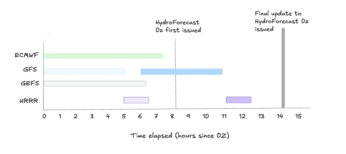
Initialization and issue times
The initialization time marks the start of the forecast period. It's when the model takes a "snapshot" of current conditions — like snowpack, soil moisture, and recent streamflow — to begin its calculations. The issue time is when the finished forecast is published and ready to use. There's always a short gap between the two, not because of inefficiency, but because the model waits for the latest weather data to be processed and released before it can generate a forecast.
Learn about weather input timing in HydroForecast.
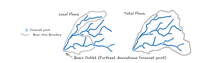
Local and total flows
Local flows refer to the movement of water within a smaller part of the basin subtracting a portion of the upstream area. These represent flows that only include a subset of the total upstream contributing area (i.e. the area 'local' to the forecast point). These are often used if there is an upstream reservoir that functionally removes a portion or substantially alters a portion of the upstream contributing area to a forecast point.
Total flows include all upstream basin contributions. HydroForecast can forecast both, depending on what's needed and work closely with customers at the setup stage to consider how best to set up our model and forecast points.
Regulated and natural flows
Natural flows are what you'd expect in a river without human intervention (no dams, no diversions). Most of the time, HydroForecast is modeling these. But in some cases, we can incorporate regulation — like known or planned reservoir releases — into the forecast, depending on the data available.
Measuring accuracy and building trust
How do we know if a forecast is any good? These metrics help quantify performance and demonstrate that HydroForecast delivers reliable predictions.
Evaluations
Evaluations are checks we do to see how the model is performing. We look at statistical metrics like root mean square error (RMSE) and bias to track performance and guide improvements. It's part of our commitment to continuous improvement, not just one-off accuracy.
Check out our webinar on strategies for evaluating hydrology forecasts.
RMSE (Root Mean Square Error)
A common metric for measuring forecast accuracy. It calculates the average magnitude of forecast errors, with larger errors weighted more heavily. Lower RMSE means better accuracy. RMSE is expressed in the same units as the forecast (e.g., cubic feet per second), making it easy to interpret.
Reforecast (also known as a hindcast or backcast)
A reforecast is a forecast made in hindsight — using only the data that would have been available at the time. It's a way to simulate how the model would have performed in past conditions. We use reforecasts to evaluate accuracy, improve the model, and build confidence that it can handle real-world variability across different hydrologic conditions — drought, flood, and everything in between.
Keep learning
These terms cover the essentials, but there's much more to explore. The intersection of AI, machine learning, and hydrology is evolving rapidly, and we're committed to keeping our systems at the leading edge while translating technical advances into practical operational value.
HydroForecast is built to be powerful and flexible. And while the underlying tech is complex, your experience with it shouldn't be. If you're curious how this all fits together for your specific operations, get in touch to go deeper.

